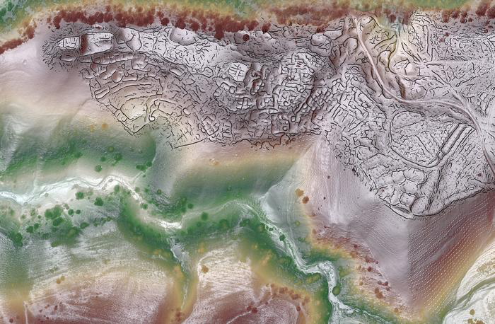
For the first time, archaeologists have used drone-based lidar technology in Central Asia to uncover remarkable details about two previously undocumented trade cities nestled high in the mountains of Uzbekistan.
The cities, just 5 kilometers apart, have revealed fascinating insights into the region’s history and urban development. These long-lost hubs of commerce are providing new perspectives on trade and life along the historic Silk Road.
A team of researchers, led by Michael Frachetti, a professor of archaeology at Washington University in St. Louis, and Farhod Maksudov, director of the National Center of Archaeology in Uzbekistan, utilized this cutting-edge technology to map the size and layout of these medieval cities at high altitudes.
Ancient Cities Hidden in the Mountains
The newly discovered cities, Tashbulak and Tugunbulak, are perched at elevations between 2,000 and 2,200 meters above sea level, comparable to the altitude of Machu Picchu in Peru.
These heights make them extraordinary examples of thriving urban centers in mountainous regions. Tashbulak, the smaller of the two, spans 12 hectares, while Tugunbulak covers a vast area of 120 hectares.
“Tugunbulak is one of the largest cities in the region during its time. These cities were significant urban hubs in Central Asia, especially as you moved out of lowland oases into more challenging high-altitude environments,” Frachetti explained.
Positioned strategically along the Silk Road, the cities served as vital centers for interaction, challenging the common perception that mountains hindered trade routes. On the contrary, the mountainous terrain may have spurred economic growth, driven by resources like livestock and minerals.
According to Maksudov, the nomadic pastoralists who inhabited Tugunbulak over a thousand years ago had a distinct and independent culture. “This site had a complex urban structure with material culture that differed significantly from the sedentary lowland cultures,” Maksudov added.
Lidar Technology and Archaeological Breakthroughs
Lidar technology, commonly used to penetrate dense vegetation in archaeological surveys, provided detailed scans of the layouts of these cities in Uzbekistan’s arid landscape.
These high-resolution scans revealed intricate details like plazas, fortifications, roads, and habitation areas, shedding light on the communities that flourished in these high-altitude regions between the 6th and 11th centuries.
“Drone operation is highly regulated in Uzbekistan, so this discovery was made possible thanks to the political support and permissions granted by our local partners and government,” Frachetti stated in a press release. The lidar scans have produced some of the highest-resolution images of archaeological sites ever published, allowing for unprecedented levels of computer analysis.
Researchers from Washington University’s Spatial Analysis, Interpretation, and Exploration (SAIE) Lab used the drone-lidar data to create 3D models.
Professor Tao Ju, a computer scientist from Washington University, and undergraduate Xiaoyi Liu applied advanced computational algorithms to analyze the surfaces, automatically tracing millions of lines and revealing the architectural alignments of ancient cities that would otherwise have remained hidden.
“This project reflects a truly interdisciplinary effort,” Ju noted. “The techniques we’re using have potential applications in various fields that utilize lidar scans.”
A Rich History Along the Silk Road
Tashbulak and Tugunbulak were not just remote outposts but integral parts of the Silk Road’s extensive network.
Preliminary excavations at Tugunbulak have uncovered a fortified structure with three-meter-thick rammed earth walls, suggesting the city may have housed an iron ore factory that produced steel.
The presence of such industry points to the city’s economic importance. Frachetti emphasized that these findings demonstrate how Central Asia was not just a transit route between China and the West but a central player in the political and economic forces shaping the region.
“The Silk Road wasn’t just about China and the West,” Frachetti explained. “Major political powers were at play in Central Asia, and this complex heart of the network was a driver of innovation and economic development.”
This groundbreaking discovery was made possible through a combination of traditional archaeological methods and cutting-edge lidar technology, offering a detailed map of urban development in this often-overlooked region.
Frachetti and his team hope to continue using these methods to explore other high-altitude settlements along the Silk Road and beyond. “We could reshape our understanding of urban development in medieval Asia,” Frachetti said in the press release.

